 |
| One of the last remaining pieces of the wreck of the Corea in 1890. |
THAT
WHICH WE CALL A ROSE….
April 2010
Our perception of what is historically important is often
determined by the names we assign to the events or objects that reflect that
history. A name acts like a marker, reminding us of the past. Consequently, when
a name disappears, the associated history tends to follow. For example:
Mike Steik, who was born in Ninilchik in 1934, can remember
an old marine navigation map that he once kept rolled up in his boat when he
fished commercially in the early 1950s. On that map, just south of Corea Creek,
lay a stretch of shoreline clearly labeled “Corea Bend.”
Since he stopped fishing after he was drafted into the
military in 1956, Steik said he has lost track of that map, and he can’t
remember seeing one since that featured the name “Corea Bend.”
Ninety-two-year-old Nick Leman, who was born in Ninilchik in
1917 and honeymooned with his wife, Marian, in a small cabin near Corea Bend in
August 1947, said that that stretch of shoreline has been called Corea Bend as
far back as he can remember. His 90-year-old brother, Joe Leman, concurs.
 |
| "Corea Bend" can be seen penciled into this old map depicting east-side fish traps. |
These days, real estate maps of the area nearby—just west of
the Sterling Highway, at about Milepost 126—typically show a street called
Corea Bend Road that curls along the southern edge of Corea Bend Subdivision. Some
such maps may show and label tiny Corea Creek, but they will not show Corea
Bend itself.
In his 1971 Dictionary
of Alaska Place Names, Donald J. Orth offers a specific entry for Corea
Creek—including its origin dating back to a 19th-century shipwreck
in the area—but does not even mention Corea Bend.
And Alaska historian Robert N. DeArmond, who founded the
Alaska Northwest Publishing Company, wrote in the 1970s that Corea Bend used to
appear on local maps and charts but had been “unfortunately” omitted from more
recent editions.
The reasons for this cartographical vanishing act are
unclear. Perhaps Corea Bend owes its disappearance to its lack of geographical
prominence, since it neither juts outward like Anchor Point nor sags inward
like Chickaloon Bay. It is not even as clearly defined as the mile-long Corea
Creek near its northern head.
In fact—since the bulk of the shipwreck was likely pillaged
early on by scavengers and then pulverized more than a century ago by the forces
of ice and tide—the creek is the only named physical reminder of an incident
that shook up the fledgling Cook Inlet cannery world 120 summers ago.
The three-masted wooden bark Corea was built in Boston in 1868, and she began making supply and
passenger runs from San Francisco to Cook Inlet in the spring of 1885. On her
fateful final voyage, she departed the California port on March 27, 1890, and
nearly a month later she was cruising up the inlet when disaster struck.
 |
| The Corea hard aground below Kalgin Island, 1890. |
In “thick weather” at about 3 a.m. on April 23, and running
against a strong outgoing tide, according to the official Wreck Report filed
for the ship’s owner, the Arctic Fishing Company, she ran hard aground of a
sandbar approximately six miles south of Kalgin Island. There, below a landmark
that on an 1802 map had been named Isla
de Peligro (or “Island of Danger”), her voyage halted as the tide continued
to ebb, and within a few hours she sat high and dry.
An 1890 photograph (from the H. M. Wetherbee Collection)
taken of the Corea early the following
morning shows her sails at half-mast, her hull almost entirely on dry land, men
on her deck, the seas calm, and a stack of her coal and some other materials in
two separate piles alongside her keel.
This photo also clearly illustrates the impressive size of
the vessel: 133.4 feet from bow to stern, 31.5 feet from port to starboard, and
18 feet deep. She weighed nearly 565 tons and had been carrying a cargo
weighing about 500 tons—mostly coal and cannery tin and other cannery
supplies—in addition to a 19-man crew and 97 passengers, 77 of whom were
Chinese laborers bound for work at the Kasilof cannery, according to “Canneries
of Kasilof and Kenai, 1889-1896,” a Wetherbee photographic display at Kenai
Peninsula College.
After striking the sandbar, according to a May 1890 article
in the Daily Alta California, “the
crew and Chinese passengers were put to work at the pumps.” The ship’s master,
Captain H.H. Wheeler, then waited for the tide to rise again and assessed the
damage.
 |
| The Corea, beached on what became known as Corea Bend, 1890. |
The Wreck Report states: “Got her off the reef and found the
vessel was filling”—12 feet of water in the hold, according to a notation on
the Wetherbee photograph—“so ran her 25 miles in sinking condition to East
shore of Cook’s Inlet and beached her.”
Wetherbee photos of the second beaching site clearly show
that the vessel rammed ashore at the mouth of what would become known as Corea
Creek, about 15 miles south of the canneries on the Kasilof River. One of those
photos also shows shipwrecked passengers and crew from the Corea encamped along the shoreline near the creek mouth.
At this camp, according to oral history collected by Bobbie
Oskolkoff of Kenai, was Oskolkoff’s great-grandfather, Robert James Kelly, who
at some point walked north with a group of the Chinese laborers to the Arctic
Fishing Company cannery at the Kasilof River mouth.
 |
| Crew and passengers of the Corea, encamped on the east-side beach. Note the break in the bluff in the background: That is the mouth of Corea Creek. |
Although these men were likely seeking employment, it is
unknown what they found. Because of the wreck, AFC did no canning in the summer
of 1890. A second Kasilof cannery was built that same year by George W. Hume
and, according to the KPC display, the Hume cannery became the primary
operation in Cook Inlet that year because of the shipwreck of the Corea.
Articles in both the Daily
Alta and the San Francisco Call
from the summer of 1890 state that, after the beaching, nearly every movable
item on the ship was brought ashore and saved, and parts of the ship were
dismantled.
“A survey was held on the bark and resulted in her being
condemned. She was afterwards sold as she lay for $355,” said the Daily Alta. The Call referred to the sale as an “auction” and said that both “the
cargo and hull” were sold together.
According to two separate articles in the Daily Alta, most of the crew and
passengers, all of whom survived, were eventually were rescued by another
member of the AFC fleet, the steamer Francis
Cutting, which hauled the men to Kodiak.
At some point in May, the steamer Bertha carried Captain Wheeler, Chief Mate Oliver, the second mate
and two seamen from the Corea back to
San Francisco. Some of the rest of the “crew and fishermen” from the Corea were returned to San Francisco
later that summer aboard the schooner Glen.
Ultimately, as stated in the Wreck Report and attested to by
AFC owner/manager F.P Kendall, insurance covered most of the losses—except
those incurred by the cannery. The vessel had been valued at $15,000 and
insured for $12,500, and its cargo had been valued at $45,000 and insured for
$41,600.
Today, only one remnant of the Corea is still known to exist. Although it has been shoved south
along the shoreline far from its original resting place, and can be seen only
when the tides along Corea Bend are quite low, the approximately 80 feet of
water-logged beams serve as a reminder of both the power of nature and the
importance of this local historical event.
Someday, however, the wearing actions of tide and time may
erode the last bits of the old wooden bark, the name of the tiny stream at the
wreck site may fade from all maps and charts as did the stretch of beach, and
the wreck of the Corea will become
little more than an interesting factoid glimpsed by researchers studying the
history of Cook Inlet fisheries.
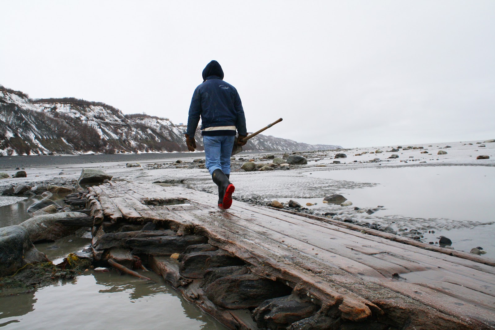 |
| Examining a big piece of the old wreck. |
No comments:
Post a Comment